California Coast, USA road trip
Pacific Coast Highway Road Trip itinerary
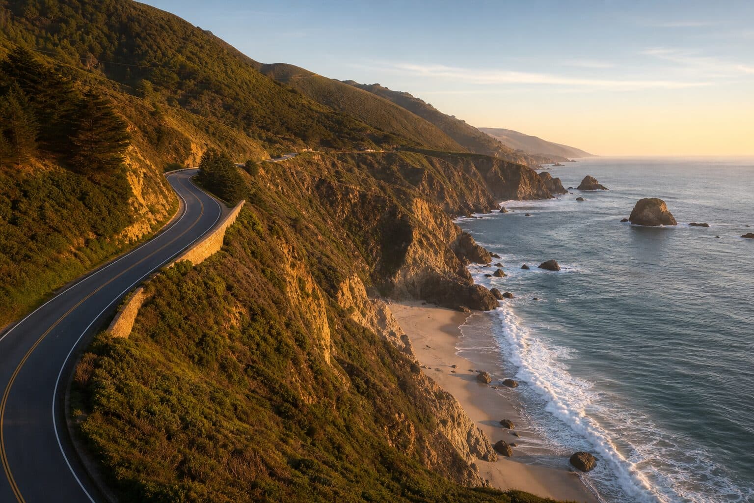
A Pacific Coast Highway road trip is the definitive way to see the California coast: a slow, cliff-hugging run down Highway 1, the road most people simply call the PCH. This itinerary drives the full length from San Francisco to San Diego, around 600 miles over seven days. It is a longer trip than the classic San Francisco to Los Angeles dash, carrying on past LA through the Orange County beach towns to finish in San Diego, so you get the famous Big Sur cliffs and Hearst Castle as well as the laid-back surf coast of the south. Highway 1 is slow by design, so the days are built around viewpoints and beach stops rather than mileage.
- Duration
- 7 days
- Distance
- 600 miles
- Start and finish
- San Francisco to San Diego (north to south)
- Best time
- September and October are the sweet spot — warm, clear and quieter once the summer crowds thin out, with late spring a close second. High summer is busiest and often brings morning coastal fog along Big Sur and the southern beaches. Winters are wetter, and the Big Sur stretch of Highway 1 can close after storms, so check conditions before a cool-season trip.
See the ready-made plan
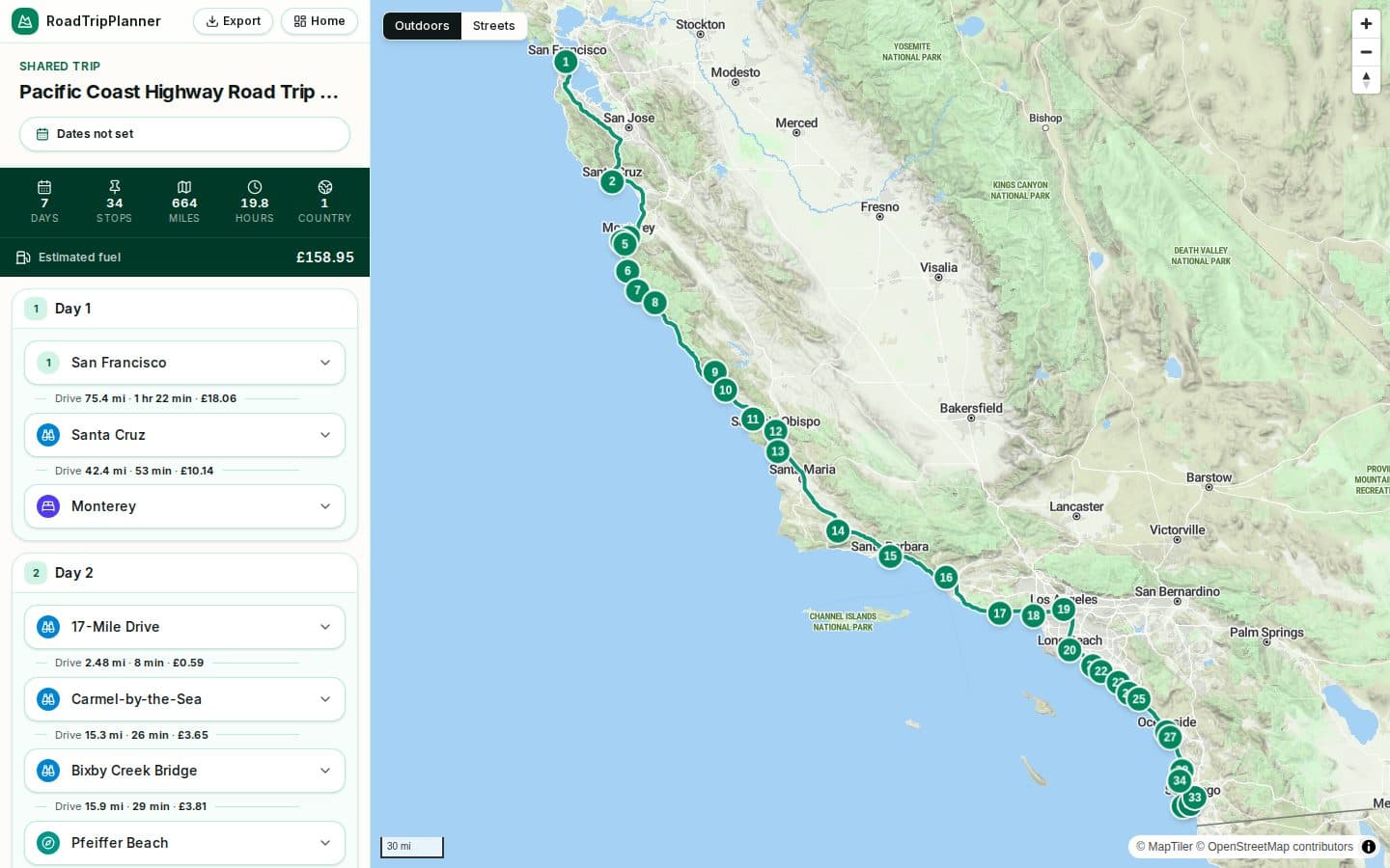
The full Pacific Coast Highway Road Trip itinerary is already plotted in the planner, day by day. Open it to see the route on the map, then drag stops, add your own and keep notes as you go.
Why drive the Pacific Coast Highway Road Trip?
A 7-day Pacific Coast Highway road trip down California's Highway 1 from San Francisco to San Diego, with Big Sur, real towns, distances, the best viewpoints and when to go.
- Monterey, Carmel and the Big Sur cliffs
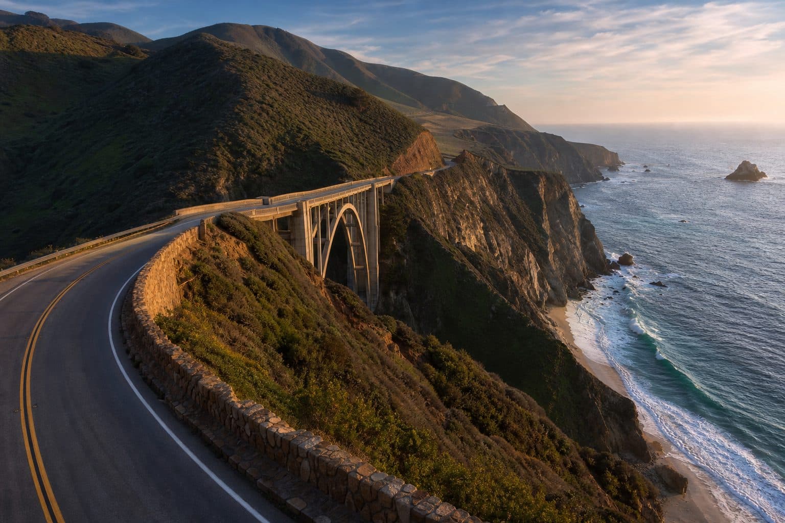
- Bixby Creek Bridge, McWay Falls and Hearst Castle
- Santa Barbara, Malibu and the Santa Monica coast
- The Orange County beaches, La Jolla and San Diego
7 days Pacific Coast Highway Road Trip itinerary
Day 1
San Francisco to Monterey
Leave San Francisco and follow the coast south through the surf town of Santa Cruz, then round Monterey Bay to Monterey, with its old Cannery Row waterfront. It is about 120 miles, leaving the afternoon free for the harbour and aquarium district.
Day 2
Monterey to Cambria via Big Sur
The showpiece day, around 95 miles. Take the 17-Mile Drive and pretty Carmel-by-the-Sea, then drive the heart of Big Sur — Bixby Creek Bridge, Pfeiffer Beach, the redwoods of Pfeiffer Big Sur State Park and McWay Falls — before Hearst Castle above San Simeon and a night in arty Cambria.
Day 3
Cambria to Santa Barbara
Continue through Morro Bay under its volcanic rock to San Luis Obispo and the dunes and pier at Pismo Beach, then loop inland to the Danish-style village of Solvang and the Santa Ynez wine country before rejoining the coast at Santa Barbara — roughly 140 miles.
Day 4
Santa Barbara to Los Angeles
Enjoy Santa Barbara's red-tiled roofs and palm-lined waterfront, then follow the coast past Ventura and onto the Pacific Coast Highway through Malibu, with its long beaches and clifftop viewpoints, finishing at Santa Monica Pier and Los Angeles — about 100 miles.
Day 5
Los Angeles to Dana Point
Trace the Orange County coast, around 60 miles, through Long Beach, the surf pier at Huntington Beach and the harbour at Newport Beach, then on to the artists' colony of Laguna Beach and the marina town of Dana Point for the night.
Day 6
Dana Point to San Diego
Follow the southern coast about 75 miles through San Clemente, the seaside missions and beaches of Oceanside and Carlsbad, and the bluffs at Torrey Pines to La Jolla's coves, finishing in San Diego.
Day 7
San Diego
Finish with a day in San Diego: the tip of Point Loma and the Cabrillo National Monument, the beaches of Coronado, the museums of Balboa Park and the seals and sea lions back at La Jolla Cove.
Planning tips
Drive it north to south
Heading from San Francisco towards San Diego keeps you on the ocean side of Highway 1, which makes pulling into the clifftop viewpoints and beach lay-bys far easier and safer.
Check Highway 1 before you go
The Big Sur section is prone to landslides and storm closures, especially in winter and spring. Check the Caltrans QuickMap for any closures so you can plan an inland detour around Big Sur if needed.
Allow more time than the mileage suggests
The distances look modest, but constant viewpoints, slow coastal bends and busy summer traffic mean each day fills up quickly. Build in stops rather than chasing the next town.
Skip the car in the big cities
Driving and parking in San Francisco, Los Angeles and central San Diego is slow and expensive. Use public transport or park-and-ride in the centres and save the car for the open coast road.
Pacific Coast Highway Road Trip FAQ
How many days do you need for a Pacific Coast Highway road trip?
Allow about a week to drive the full Pacific Coast Highway from San Francisco to San Diego at a comfortable pace. With three or four days you can still drive the best stretch from San Francisco to Los Angeles, taking in Monterey and Big Sur.
How long is the Pacific Coast Highway?
California's Highway 1, the road most people mean by the Pacific Coast Highway, runs roughly 650 miles along the coast. This San Francisco to San Diego road trip covers around 600 miles of it, including the famous Big Sur section.
Where does the Pacific Coast Highway road trip start and finish?
This itinerary runs north to south from San Francisco to San Diego. You can drive it in either direction, but southbound keeps you on the ocean side of the road for the best views and easiest stops.
When is the best time for a Pacific Coast Highway road trip?
September and October bring warm, clear weather and thinner crowds, with late spring a close second. High summer is busiest and often foggy in the mornings along Big Sur and the southern coast.
Is Highway 1 through Big Sur open?
Big Sur's stretch of Highway 1 occasionally closes after winter storms and landslides. Check the Caltrans QuickMap for current conditions before you set off, and have an inland detour in mind just in case.
Related road trips
California Road Trip
Drive the California coast on Highway 1 from San Francisco to Los Angeles — Monterey, Big Sur, Hearst Castle, Morro Bay and Santa Barbara along the way.
- Duration
- 5 days
- Distance
- 470 miles
Oregon Coast Road Trip
Drive the full Oregon Coast on US-101 from Astoria to Brookings — sea stacks, lighthouses, the Oregon Dunes and the Samuel H. Boardman corridor.
- Duration
- 5 days
- Distance
- 363 miles

East Coast Road Trip
Drive the US East Coast from Boston to Miami — New York, Washington DC, the Outer Banks, Charleston, Savannah and the Florida coast in one classic itinerary.
- Duration
- 12–14 days
- Distance
- 1,500 miles